Still no answers about this type of problem with place names - is it a FamilySearch or FMP matter?


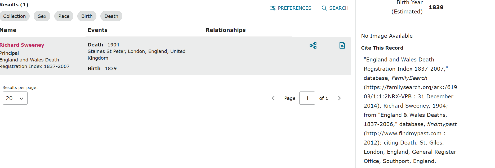
Nothing wrong with the above - both the GRO index and FreeBMD shows the same. BUT look at what the Search page result shows:

I have reported this type of problem before (with census results showing "Cleveland, Yorkshire" as the event place for places that are not in that area.
Further screenshot illustrates citation details:
Best Answer
-
Looking at the same record on FMP, the location is straightforward - District: St Giles; County: London; Country: England.
If I had to guess, it would be something in the coding when the index from FMP is imported - some conflict in the way places are interpreted.
I know there have been similar issues with locations in New York when an FMP index was imported into FS - with Kings County (Brooklyn, New York City) being interpreted as Saratoga County. Probably others, but that's one I've run into often in my NY research.
1

Answers
-
Thank you for your response. It came through just as I was editing my post to show the citation detail.
This is yet another major "place name problem" I am experiencing - especially with those "Cleveland, Yorkshire" census records (thousands of them) that are for places many miles from that part of Yorkshire.
Sadly, I do not believe FamilySearch will either acknowledge the problem or try to explain it "officially" - let alone working (possibly with FMP) in an effort to rectify it.
BTW - this is from Wikipedia:
Staines-upon-Thames is a market town in northwest Surrey, around 17 mi (27 km) west of central London. It is in the Borough of Spelthorne, at the confluence between the River Thames and River Colne. Historically part of Middlesex, the town was transferred to Surrey in 1965.
Staines has never been part of London - as can be seen, when the county of Middlesex was absorbed into Greater London in 1965, Staines became part of the county of Surrey. There is St. Peter's church in Staines, but it has no connection with this death whatsoever.
1 -
@Paul W re Staines (and many others, e.g Loughton) It's a sign of the times I'm afraid. To some, if it's inside the M25 ringfence, then it's London. Being more general though, as an effect of the expansion of the railways many villages became engulfed in nearby places because they became known after the town that had the station. From the 1880s forward that created regional confusion. Then came boundary changes. Then metroplolitan boundary changes. Then Postal area changes. Then a special kind of change that was the first form of 'levelling up': which moved politicallly sensitive areas into a single unit, hence enabling the remaining area to be politically unifed, and consequently a safe seat. Just for amusement, take a look at the boundaries that were created by telephone regions, or postcodes. They would make a good study case for social geography. As a hint: (UK only i'm afraid, sorry cousins!) look at the derivation of STD codes. Some of them are named after river valleys.
1
