help transcribing ca. 1863 U.S. land description

Hello,
Would anyone like to take a shot at helping me transcribe the following image? It comes from an estate record in Missouri from about 1863. So it seem to be using the Range, Township, Section arrangement (Public Land Survey System). Here is what I have:
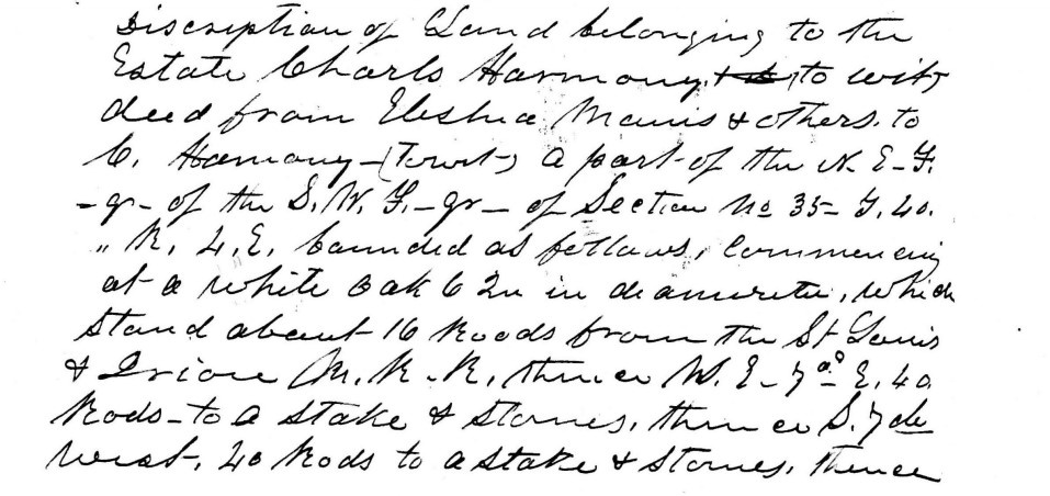
Description of land belonging to the
estate Charls Harmony to wit
deed from Elisha Manis(?) & others to
C. Harmony – (to wit) a part of the N.E.F.
-gr-of the S.W.F-gr-of Section no 35 T. 40
“ R. 4. E. bounded as follows, commencing
at a white oak 62 in in diameter, which
stand about 16 roods from the St. Louis
& Irion M. R. R. thence W. (?) 7˚ E. 40
rods to a stake & stones, thence S. 7(?)
west, 40 rods to a stake & stones, thence
But it doesn't fully make sense. What I see as an "F" in N.E.F. and S.W.F. is clearly "North East" and something; "South West" and something. It would typically be followed by "quarter" or "half". Perhaps what I have as "gr" is really "qr" and is an abbreviation for "quarter"? Is the "F" really an "F" at all? The St. Louis and Iron Mountain Railroad was a real thing and I believe it would have run through the general vicinity where the property was (De Soto area, Jefferson County, Missouri).
Thank you for any help!
Answers
-
From AI . . .Land grant documents from that era, especially those related to the Homestead Act of 1862 or the Morrill Act of 1862, . . . The "N.E.F." indicated a specific 160-acre plot of land (a quarter section) within a larger surveyed area. "Sec. 35 T 40" refers to a specific, standardized legal description of a 640-acre square of land, which is divided into 36 one-square-mile sections. T 40 is the township, and Sec. 35 is the 35th section within that township. "roods" is rods and "Irion" is Iron.
0 -
@Hugh Williams Not sure that those are Fs. I have seen it SW4 (meaning South West 1/4), but then the 'gr' symbol doesn't make sense. I can tell you that the second to last line says "S 7 de. [degrees] West…" I would recommend you reach out to the county clerk in Jefferson county and see if these are a peculiar notations that they used in that area. Possibly check with a local historical society to see if someone there knows.
0 -
@Hugh Williams - Sorry, I should have been more forthcoming in my earlier comment, As @AnneLoForte Willson states, the F is possibly a transcription error or a less common abbreviation for "Four" or "Fourth", indicating the "Quarter" division (1/4). Given the time period, I'd say the F does indicate Fourth 😎
1
